History
The Huckleberry.
In 1904 a coal railroad left the Norfolk and Western at Cambria, in what is now Christiansburg, for the mines at Merrimac and the college town of Blacksburg. Riders called it the Huckleberry. Its last train ran in 1966, and its bed became the paved trail between the two towns.
1904
First train to Blacksburg
From Cambria, by Christiansburg
8.9
Miles of track
Cambria to Blacksburg
15
Miles of paved trail
With Huckleberry North
13
Neighborhoods beside it
On this site
Chapter 1
1902 to 1904
A railroad for coal.
Hard coal lies under Price Mountain and Brush Mountain, between Blacksburg and Christiansburg, and people had dug it for a century. Getting it out was the trouble. The Norfolk and Western main line ran through Cambria, at the edge of Christiansburg, miles from the mines, and in the late 1800s nobody raised the money for a branch line.
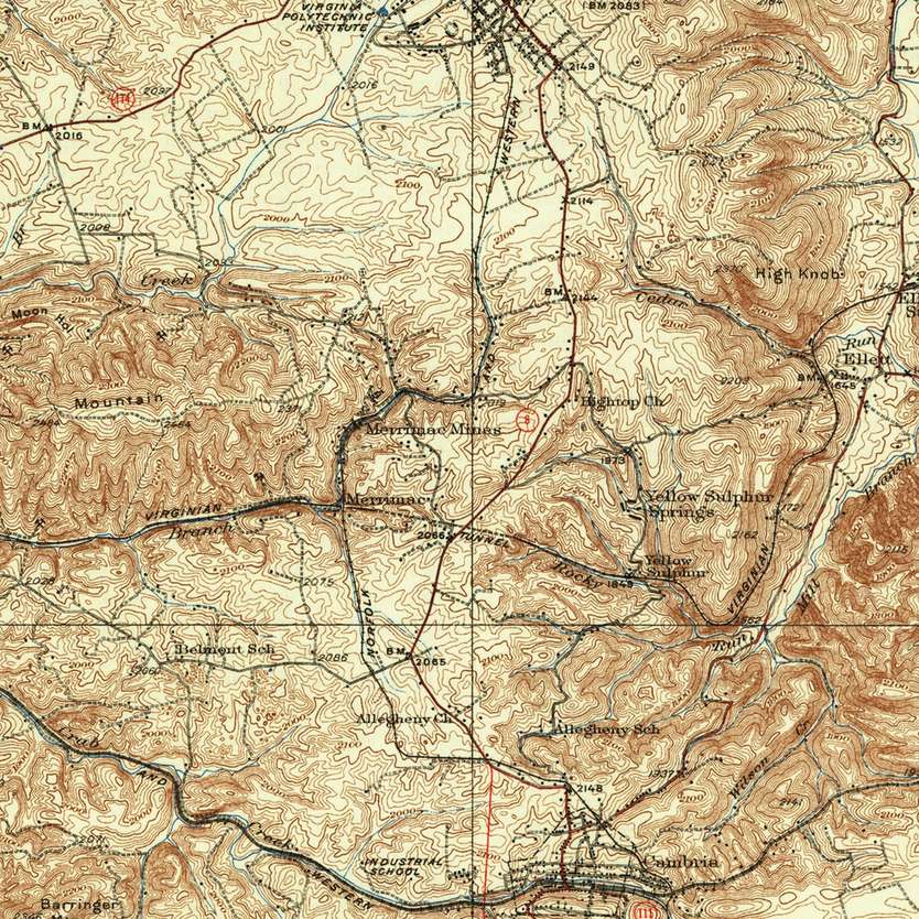
In 1902 the Virginia Anthracite Coal and Railway Company began one. Its spur ran from the Norfolk and Western at Cambria north to the company’s Merrimac Mine on Price Mountain, and on to Blacksburg under a contract with the college, then Virginia Polytechnic Institute. L. S. Randolph, head of the college’s mechanical engineering department, was in charge of the work. Crews built the single track with hand tools and horse-drawn equipment, and it took two years.
On September 15, 1904, the first passenger train made the run from Cambria to Blacksburg in about 40 minutes, with free rides for all. The first train of cadets came in six days later. The Blacksburg end of the line stood near today’s Blacksburg Library.
.jpg)
Chapter 2
1904 to 1958
Riders called it the Huckleberry.
The line climbed through long U-shaped curves, and the train was slow. Students, the story goes, stepped off as it entered a curve, picked huckleberries across the field and climbed back on as it came out. When it stalled, riders did the same. Upperclass cadets painted “Huckleberry Crossing” on the depot, and the name stuck to the whole line.
At first there were four runs a day, three of them carrying the mail. A rider with one bag paid half a dollar from Cambria to Blacksburg; without baggage, 35 cents. From 1912 to 1922 the Huckleberry was Blacksburg’s main link to the outside world, with three runs a day of 50 to 60 passengers each. It took the corps of cadets and the Highty-Tighties, the college band, to Roanoke for the Thanksgiving football game against the Virginia Military Institute.
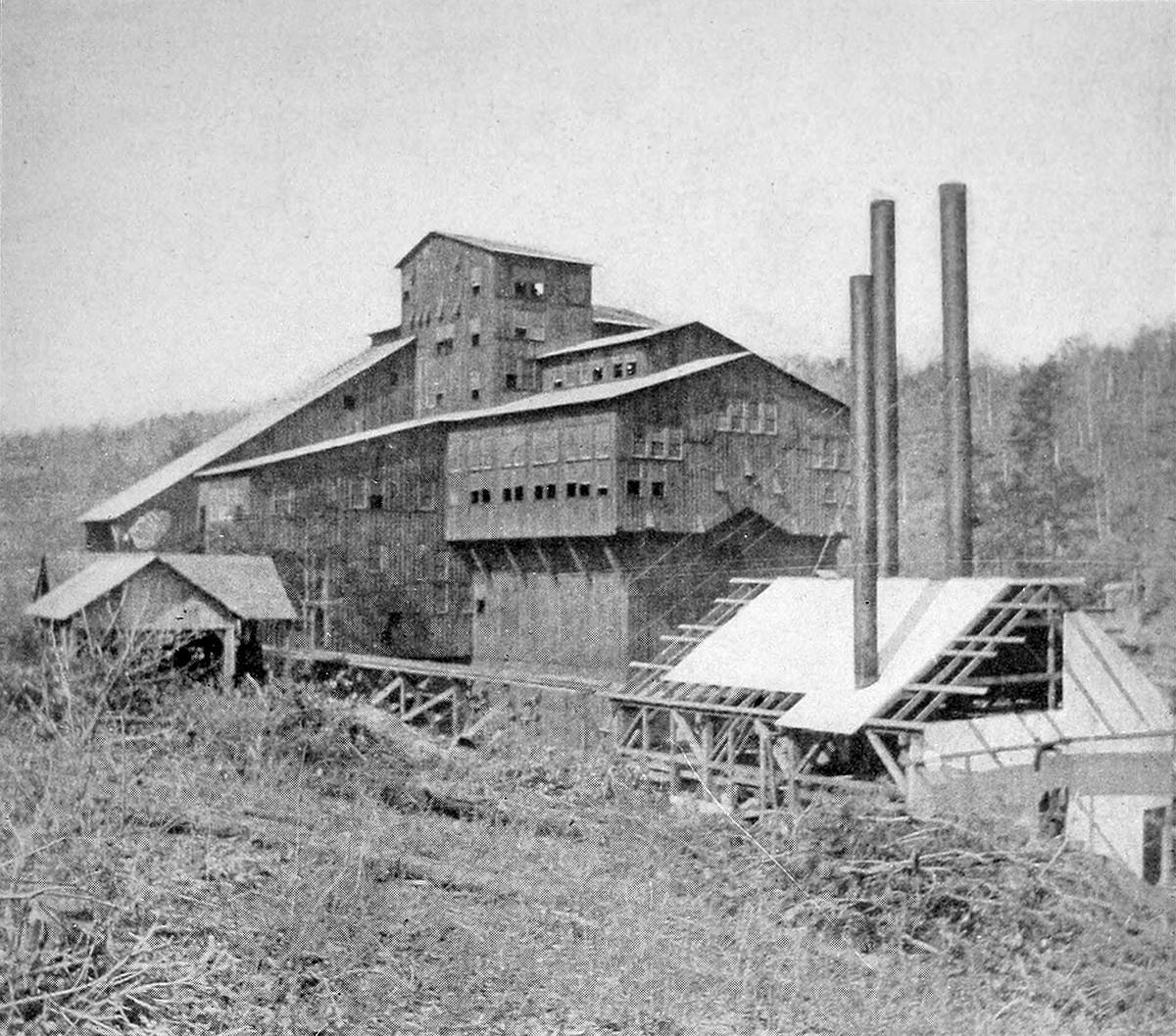
Coal was the freight. The company built a coal breaker at Merrimac, and the mine shipped about 4,000 tons a month, or 100 carloads, to buyers outside the county and to local forges, the Kingston iron mine and the college’s power plant. Coal from mines on Brush Mountain came to the tracks by truck. Merrimac grew into a coal town, an older village around the Linkous store and a newer section of 77 company houses and a commissary. When the Virginian Railway came through in 1907, it passed under a Huckleberry trestle near the Merrimac tipple and loaded coal there too.
At the south end, Cambria was a village of about 500 at the junction, with three hotels, two grist mills, a furniture maker and a lime kiln. In 1906 the railroad built a new passenger station there and made the old depot a freight station.
The Merrimac Mine flooded in 1909. The coal company sold the line to the Norfolk and Western, which named it the Blacksburg Branch in 1911 and built a proper station in Blacksburg. The mines along the line kept working: in 1918 two of the Virginia Anthracite Coal Company’s mines produced 79,554 tons.
Chapter 3
1930s to 1966
The last trains.
Cars and better roads emptied the train. By the early 1930s, the long waits meant only freshmen rode regularly, though many students still bought round-trip tickets to ship their trunks to and from Christiansburg. Passenger service fell to twice a day in the 1940s and once a day in the 1950s.
The last steam run came on July 25, 1958, and passenger service under other power ended on August 9. Freight kept the branch alive a few years more: the last freight train came into Blacksburg on June 30, 1966, and the Blacksburg station closed that summer.
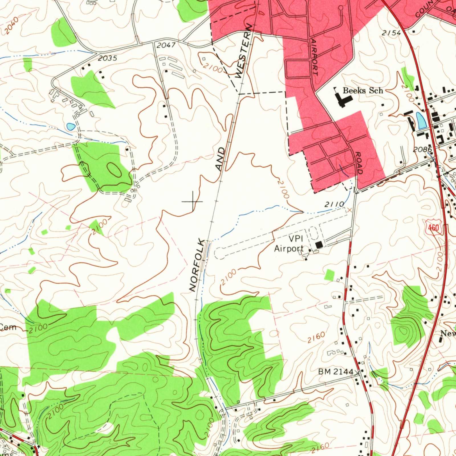
The Norfolk and Western abandoned the line to Cambria in 1966. Its end gave the college room to lengthen the runway of its airport, which the federal survey of the mid-1960s shows stopping just short of the tracks.
Chapter 4
1966 to 2009
From rail bed to trail.
The idea came almost as soon as the trains stopped. In 1966 J. C. Garrett of Virginia Tech’s horticulture department and others proposed turning the old line into a nature and walking trail, and about a mile of it, between the Blacksburg Library and Airport Road, became one.
The rest waited more than twenty years. In 1989, under Mayor Roger Hedgepeth, Blacksburg began work to carry the trail on toward Christiansburg. In July 1991 a committee of Montgomery County, Christiansburg and Virginia Tech became the nonprofit Friends of the Huckleberry. Its founders wanted more than a path: a linear park from Christiansburg to the national forest north of Blacksburg.
Students helped. Virginia Tech’s student chapter of civil engineers gave more than $40,000 worth of surveying, planning and design, and along the old bed the surveyors found a beaver dam, mining artifacts and a good stand of blackberries. In April 1992 a Huckleberry Trail Festival brought a historical bicycle tour and hikes.
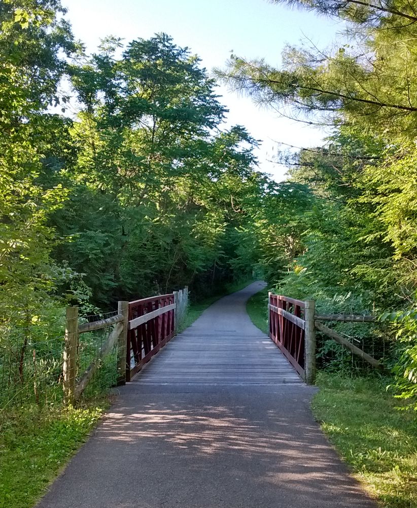
Through the 1990s the paved trail grew to about six miles, and until 2010 it ended behind the New River Valley Mall.

Chapter 5
2010 to 2025
Into Christiansburg.
Christiansburg carried the trail the rest of the way in pieces. In 2010 it was extended from the mall to the north side of Peppers Ferry Road, Route 114. In 2012 a section was finished from the Recreation Center to Forelmont Street, and in 2014 the two ends were joined from the south side of Route 114.
The crossing came last. In July 2015 the Virginia Department of Transportation finished a bridge for the trail over Route 114 as part of widening the road; it is the Renva Knowles Bridge, named for the donor whose major gift helped pay for it. Later phases carried the trail on to Cambria Street, along it to the trail at the Recreation Center, and to the shopping center on North Franklin Street.
The newest section was finished in May 2020: from that shopping center to Christiansburg High School on Independence Boulevard. It cost about $1.3 million, about $960,000 of it from the state’s Transportation Alternatives program.
Beside the trail, in 2013 the Town paid $2.5 million for 63 acres of farmland off Peppers Ferry Road, and in 2023 it opened there as Christiansburg Huckleberry Park.
And trains are coming back to Cambria, where the Huckleberry began. Ground was broken there in April 2025 for a passenger rail station, the first passenger service in the New River Valley since 1979.
Chapter 6
Huckleberry North
North to the mountain.
The founders’ goal, the national forest, came within reach from the north end. Huckleberry North, just over five miles long, leaves the original trail at a traffic circle west of Route 460, runs northeast through Hethwood, crosses Prices Fork Road and goes north to Glade Road. There it enters Heritage Park, on the former Brown farm, where paths lead to the Jefferson National Forest’s Gateway Trail, the Poverty Creek trails and Pandapas Pond, with Brush Mountain in view.
In May 2026 the Meadowbrook Greenway opened into Heritage Park. With it, a rider can go from downtown Blacksburg into the Jefferson National Forest almost entirely on trails away from traffic. The Huckleberry is now the spine of a 60-mile network of paved and natural trails, among them Coal Mining Heritage Park, McDonald Hollow, the Gateway Trail and Poverty Creek.
Chapter 7
Christiansburg to Blacksburg
Along the trail today.
From the Christiansburg end the trail starts at Christiansburg High School on Independence Boulevard and runs north past the shopping center on North Franklin Street to the Recreation Center. From there it crosses Peppers Ferry Road on the Renva Knowles Bridge and passes Huckleberry Park and the back of Uptown Christiansburg, the old New River Valley Mall, before it crosses the Norfolk Southern tracks on a bridge and heads north to Merrimac.
From the Recreation Center it is about 7.5 miles to the Blacksburg Library. About halfway, the parking at Hightop and Merrimac Roads serves both the trail and Coal Mining Heritage Park, on the ground of the Merrimac mine; the lot behind Uptown Christiansburg, near the cinema, is another start.

The neighborhoods on this site that the trail runs through or beside, within about a quarter mile: Clifton, Villas at Peppers Ferry, Peppers Crossing, Oak Tree, Vistavia, Suburban Hills, Hunters Ridge, Lions Gate, Cambria Crossing, Henley Place, Sleepy Hollow, Ridinger Acres and Windmill Hills.
Timeline
The Huckleberry, year by year.
From the first rails to the newest trail.
The 1900s
1902
Work begins
The Virginia Anthracite Coal and Railway Company starts its line from Cambria.
1904
First train
The first passenger train reaches Blacksburg on September 15.
1907
The Virginian
The Virginian Railway passes under the line at Merrimac.
1909
Flood
The Merrimac Mine floods.
1911
Blacksburg Branch
The Norfolk and Western, now the owner, renames the line.
1958
Last passengers
The last steam run on July 25; passenger service ends in August.
1966
Last freight
The last freight train reaches Blacksburg; the line is abandoned and the first mile of trail opens.
1989
Toward Christiansburg
Blacksburg begins work to extend the trail.
1991
Friends
The Friends of the Huckleberry is founded in July.
The 2000s
2010
Past the mall
Christiansburg extends the trail to Route 114.
2015
The bridge
The trail crosses Route 114 on its own bridge.
2020
The high school
The section to Christiansburg High School is finished in May.
2023
Huckleberry Park
Christiansburg’s park beside the trail opens.
2025
Rail returns
Ground is broken for a passenger station at Cambria.
2026
Into the forest
The Meadowbrook Greenway links Heritage Park.
Sources
Every historical fact on this page comes from a source below, read on the date shown. The railroad’s story comes mostly from Virginia Coal: An Abridged History and the Spring 1992 Virginia Tech Magazine; the trail’s from the Friends of the Huckleberry Trail, Montgomery County and the Town of Christiansburg. Where sources disagree or a record could not be checked, the fact is left out. Something to add or correct? Tell us.
- Walter Hubbard and others, Virginia Coal: An Abridged History (Virginia Center for Coal and Energy Research, 1990), Montgomery County chapterChecked October 14, 2026
- Virginia Tech Magazine, Spring 1992 (vol. 14, no. 3): "Huckleberry Line"Checked October 14, 2026
- Friends of the Huckleberry Trail: A History of the Huckleberry TrailChecked October 14, 2026
- Montgomery County Parks and Recreation: Huckleberry Trail (route, access points and history)Checked October 14, 2026
- National Register of Historic Places nomination: Cambria Historic District (Gibson Worsham; VLR 1989, NRHP 1991), Virginia Department of Historic Resources file 154-0048Checked October 14, 2026
- Friends of the Huckleberry Trail: the trail and the Friends (founded July 1991; a network of paved and natural-surface trails)Checked October 14, 2026
- Town of Christiansburg: Huckleberry Trail Extension (2010 to 2020)Checked October 14, 2026
- Town of Christiansburg: Christiansburg Huckleberry Park, park history and future plansChecked October 14, 2026
- Virginia Tech News: groundbreaking for the New River Valley passenger rail station at Cambria (May 2, 2025)Checked October 14, 2026
- Friends of the Huckleberry Trail: Plan Your Visit (sections and lengths)Checked October 13, 2026
- Roxy Todd, "Blacksburg continues to expand biking trails despite uncertainty over future funding," Radio IQ (WVTF), May 15, 2026Checked October 14, 2026
- OpenStreetMap: the Huckleberry Trail, Huckleberry Trail North and Huckleberry Trail South ways (trail line on the map, and the distances to neighborhoods). © OpenStreetMap contributors, ODbLChecked October 14, 2026
Images
- Blacksburg, Va. quadrangle, 1:62,500, 1937 edition, detail, 1937U.S. Geological Survey, Historical Topographic Map Collection, 1937. U.S. Geological Survey: USGS-authored or produced data and information are considered to be in the U.S. Public Domain. (Work of the U.S. federal government.)
- Coal Breaker of Virginia Anthracite Coal Company at Merrimac Mines, near Blacksburg, Virginia, 1904 (Cassier's Magazine, vol. 27, page 342)Cassier's Magazine, 1904 (public domain), via Wikimedia Commons. Published in 1904, before 1931: public domain in the United States. Wikimedia Commons records it as 'No known copyright restrictions' (Internet Archive Book Images, from the scan of Cassier's Magazine).
- Blacksburg, Va. quadrangle, 1:24,000, 1965 edition (aerial photos 1963, printed 1966), detail, 1965U.S. Geological Survey, Historical Topographic Map Collection, 1965. U.S. Geological Survey: USGS-authored or produced data and information are considered to be in the U.S. Public Domain. (Work of the U.S. federal government.)
- Huckleberry Trail with bridge over Slate Branch creek, Montgomery County, Virginia, June 29, 2016Photo: Vejlenser, CC BY-SA 4.0, via Wikimedia Commons. Creative Commons Attribution-Share Alike 4.0 International (CC BY-SA 4.0), https://creativecommons.org/licenses/by-sa/4.0/
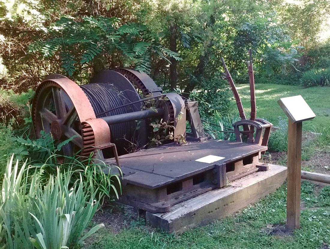
- Coal mining equipment at the Coal Mining Heritage Park, June 29, 2016Photo: Vejlenser, CC BY-SA 4.0, via Wikimedia Commons. Creative Commons Attribution-Share Alike 4.0 International (CC BY-SA 4.0), https://creativecommons.org/licenses/by-sa/4.0/